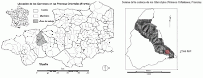
 | Location of the study area in Les Garrotxes, Eastern Pyrenees, France
Detail of the sunny area of 1km² |
 | Land use series
Chronological land use series: 1980, 1989, 1995, 2000 and 2004 |
 | Topographic map 1: 25000 / MDT / Gradients (°) |
 | Aerial photographs from 1980 and 2004: dynamics of the vegetation |
 | Land use in 1980 and 2004 (interpretation by supervised segmentation and classification) |
 | Ecobuage: Location and date of controlled fires (ecobuages) in the top part of the study area |
 | SNV30838 Vegetation typical of the sunny area: Quercus ilex, meadows and pasture |
 | View towards the north. In the background: the massif of Madrés (2469 m) |
 | To the SE from the other side of the basin. Vestiges of crops and fields on terraces. |
 | Rocky area and Volta Llarga irrigation channel in the central part of the sunny area. |